Nishandehi, or land demarcation, in Punjab is now initiated through a formal application to the Tehsildar of the relevant area rather than by approaching the Patwari directly. The application is submitted to the Tehsildar who passes an order directing the Kanungo to conduct the demarcation on a fixed date with notice served to all tenure holders. The Kanungo physically measures the land, prepares a spot memo signed by all parties, and submits a demarcation report within 15 days. The Patwari’s direct role is limited to supporting the Kanungo’s field work using the Shajra Kishtwar map. Under the Punjab Land Revenue (Amendment) Ordinance 2026, formal demarcation procedures have been codified in law for the first time, reducing reliance on informal Patwari intervention.
For decades, getting your land demarcated in Punjab meant approaching the local Patwari, often waiting for weeks, paying informal fees, and hoping the Patwari would turn up on the day agreed. The Patwari held the field map, the Shajra Kishtwar, and had the measurement knowledge, which effectively gave them monopoly control over the physical demarcation process. The 2026 reforms changed this by formalizing the Tehsildar-directed, Kanungo-executed demarcation process in statute, with a mandatory timeline and a structured report format that reduces the scope for informal discretion.
What Nishandehi Is and When You Need It
Nishandehi is the process of physically identifying and marking the boundaries of a specific piece of land on the ground, using the official survey and boundary marks established in the revenue records. It translates the khasra numbers and area measurements recorded in the Jamabandi and the Shajra Kishtwar into physical reality on the land itself.
You need Nishandehi in several common situations:
- When you purchase a property and want to confirm on the ground that what you are buying matches what is recorded in the khasra number
- When a boundary dispute arises with an adjacent landowner over where one khasra ends and another begins
- When an inheritance partition has been recorded and you need to physically identify which specific plot corresponds to your registered share
- When someone has encroached on your land and you need the official demarcation report to prove where your boundary legally falls
- When you plan to construct a wall, fence, or building and need to confirm the exact legal boundary before construction begins
- When a partition mutation has been completed and the physical separation of shares needs to be established on the ground
Without a Nishandehi report from the revenue department, boundary disputes remain legally ambiguous regardless of what the records show. The demarcation report is the official documentation that ties the paper record to the physical reality of the land.
How the 2026 Ordinance Changed Demarcation
Before the Punjab Land Revenue (Amendment) Ordinance 2026, demarcation was governed by Section 67-A of the Punjab Land Revenue Act 1967 and the associated rules, but the process in practice was dominated by the Patwari’s availability and cooperation. The Patwari carried the Shajra Kishtwar map, performed or supervised the measurements, and controlled when the actual field visit happened. This gave the Patwari the same informal leverage over demarcation that they had over mutation processing.
The 2026 ordinance introduced formal demarcation procedures as a specific reform objective. The Adalat Online analysis of the ordinance confirms that it “introduces formal demarcation procedures, digital record maintenance, and structured appellate authority, reducing ambiguity and manipulation” and that “this is expected to reduce boundary conflicts significantly.” The Nation and Business Recorder both reported that the ordinance “establishes legal procedures for land demarcation and eviction of illegal occupants” as one of its core provisions.
The practical effect of this formalization is that demarcation is now a Tehsildar-directed process with a mandatory three-month completion timeline and a 15-day reporting requirement, not an informal arrangement that depends on the Patwari’s availability. The Kanungo conducts the actual measurement. The Patwari supports the Kanungo with the field map and local knowledge but does not control the process.
The Correct Authority for Nishandehi Applications
The formal starting point for any Nishandehi application in Pakistan’s Punjab is the Tehsildar of the tehsil in which the land is located. Under the Punjab Land Revenue Act 1967, the Tehsildar is the chief officer entrusted with local revenue administration and has the authority to direct demarcation proceedings.
The Kanungo, who is the supervisor of Patwaris and operates between the Patwari and the Tehsildar in the revenue hierarchy, is the officer who actually conducts the demarcation on the ground. The Patwari participates in the field exercise using the Shajra Kishtwar, the cloth map of the estate that shows all fields with their khasra numbers and boundaries, but the Kanungo is responsible for the measurement, the spot memo, and the demarcation report.
Understanding what a Qanungo does in this context is important. The Qanungo’s role in demarcation is to verify the field measurements against the map records, sign off on the spot memo alongside the parties, and submit the formal report to the Tehsildar. This is a supervisory and certification function, not the informal facilitation role the Patwari historically exercised.
Step-by-Step Nishandehi Process
The process follows a defined sequence under the current legal framework, with mandatory steps and timelines.
Step One: Draft and Submit Your Application to the Tehsildar
Prepare a written application addressed to the Tehsildar of the tehsil where the land is located. The application must contain the following information:
- Your full name, CNIC number, and contact details
- The relationship of all co-owners or adjacent landowners to the dispute or request
- The district, tehsil, and Mauza where the land is located
- The current Jamabandi period for that Mauza
- Your Khewat number and Khasra numbers whose demarcation you are requesting
- The total area for which demarcation is being sought, expressed in kanals and marlas
- Your ownership status (owner, cultivator, or both)
- A brief statement of the reason for requesting demarcation, whether it is a boundary dispute, new purchase, partition completion, or encroachment
Submit this application directly to the Tehsildar’s office. Some areas allow the Tehsildar to be reached through the relevant Arazi Record Centre or service center. Pay the required service charges at the designated payment point, which varies by district.
Step Two: Tehsildar Issues Order to the Kanungo
On receiving your application, the Tehsildar or Naib-Tehsildar passes an order directing the Kanungo to conduct the demarcation. This order also fixes a date for the demarcation and directs that formal notice be served on all tenure holders whose land is adjacent to or involved in the requested demarcation. All parties must receive notice before the demarcation date.
This step can be completed by the Tehsildar on the same day the application is received or the next working day. The notice requirement to all tenure holders is not optional and exists specifically to prevent demarcation from being conducted without the knowledge of potentially affected parties.
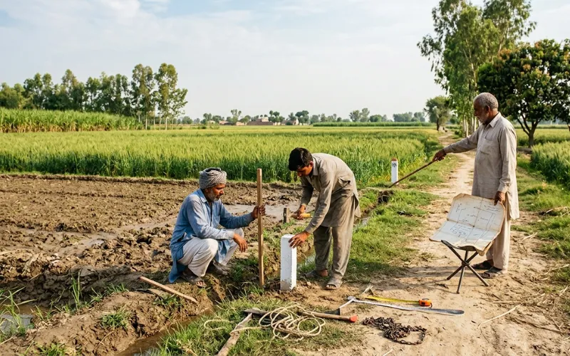
Step Three: Field Demarcation by the Kanungo
On the date fixed in the Tehsildar’s order, the Kanungo visits the land along with the Patwari and any other relevant officials. The Kanungo measures all the land from the nearest official survey or boundary mark, working outward to identify the exact boundaries of the requested khasra numbers. The Patwari’s Shajra Kishtwar, the field map, is used as the reference for the measured layout.
The measurement proceeds from the fixed survey pillars established in the official land record. These pillars, also called boundary marks or survey marks, are the physical reference points from which all demarcations in a revenue estate are calculated. If pillars are damaged or missing, this is noted and reported separately, but demarcation can still proceed from the last reliable reference point.
During the field visit, all parties who received notice should be present. Any interested party who does not appear despite receiving notice is noted in the record, but the demarcation proceeds regardless.
Step Four: Preparation and Signing of the Spot Memo
At the time of the actual demarcation on the ground, the Kanungo prepares a spot memo. This is a formal document recording the demarcation findings, the measurements taken, the boundaries identified, and the positions of the khasra numbers on the ground. All parties present sign the spot memo. The Chairman of the relevant Land Management Committee, or at minimum two independent witnesses present at the time, also sign it.
If any party refuses to sign the spot memo, the Kanungo notes this refusal in the document itself. The refusal does not invalidate the demarcation. The process continues and the refusal is handled as part of the subsequent dispute resolution if the objecting party pursues it.
Step Five: Demarcation Report Submission
Within 15 days of the actual demarcation field visit, the Kanungo must submit a formal demarcation report to the Tehsildar. This report includes the spot memo, the measurement findings, the positions of the boundaries as established, and any objections or refusals noted during the field visit. The entire demarcation process from the Tehsildar’s initial order must be completed within three months.
The demarcation report is the official document that confirms where your land boundaries legally fall according to the revenue record measurements. You can obtain a certified copy of this report from the Tehsildar’s office through what is commonly called a Nakal form or certified copy request.
What the Shajra Kishtwar Is and Why It Matters
The Shajra Kishtwar is the working field map of the revenue estate, drawn on cloth or tracing paper by the Patwari, that shows all fields in the estate with their khasra numbers and physical boundaries. It is updated whenever fields are subdivided, partitioned, or their boundaries change due to mutation orders. The Kanungo’s demarcation work on the ground uses the Shajra Kishtwar as the definitive reference for where each khasra number’s boundary should be.
Understanding the Khasra Girdawari in relation to the Shajra Kishtwar helps clarify the distinction. The Khasra Girdawari records what is happening on each field during each harvest, while the Shajra Kishtwar records the fixed physical layout of the fields themselves. Demarcation draws from the Shajra Kishtwar rather than the Girdawari because it is about physical boundaries, not cultivation status.
If the Shajra Kishtwar has not been updated after a partition mutation, the Patwari must update it before the Kanungo can conduct an accurate demarcation. This is why completing the mutation before requesting demarcation is strongly advisable.
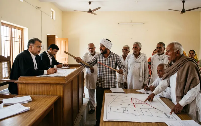
When Demarcation Escalates to a Revenue Court
If a boundary dispute arises during or after the demarcation process, and any party contests the Kanungo’s report or the measurements taken, the matter can be referred to the Tehsildar as a revenue court proceeding. The Tehsildar can hear objections, call parties before the court, and issue an authoritative order on the boundary position.
If a party remains unsatisfied with the Tehsildar’s decision, the case follows the standard revenue court appeal pathway up to the Collector and, beyond that, the Board of Revenue. Under the 2026 ordinance, only the Board of Revenue has the authority to remand cases to lower courts, which creates a more structured and predictable appellate path for disputed demarcation matters.
For disputes where encroachment has already occurred and the demarcation is needed to establish the baseline for an illegal occupation case, the Punjab Property Tribunal under the POIP Ordinance 2026 is an additional judicial channel. Encroachment cases benefit from having a completed Nishandehi report as documentary evidence of where the legal boundary falls before approaching the tribunal.
Practical Advice Before Applying for Nishandehi
A few practical steps significantly improve the outcome of a demarcation application. First, ensure your Fard is current and accurately reflects your ownership before applying. A Fard with outdated ownership information, or one that reflects a mutation that has not yet been attested, creates ambiguity during the demarcation process that can delay the report.
Second, verify that any partition mutation relating to your share in the land has been fully attested and reflected in the Shajra Kishtwar before the Nishandehi date. If the Shajra Kishtwar does not yet show the post-partition field boundaries, the Kanungo cannot accurately demarcate your specific share on the ground.
Third, be present on the demarcation date. Your absence does not stop the demarcation from proceeding but it removes your ability to observe, raise on-the-spot queries, and sign the spot memo. An unsigned spot memo creates procedural complications that are better avoided by attending.
Finally, obtain the certified copy of the demarcation report as soon as it is available from the Tehsildar’s office. Keep this document with your title papers, as it is the authoritative boundary record that will be referenced in any future dispute, construction project, or encroachment case.
Frequently Asked Questions
What is Nishandehi in Punjab’s land system?
Nishandehi is the official demarcation of land boundaries on the ground, conducted by the Kanungo under orders from the Tehsildar. It physically identifies where the boundaries of a khasra number or group of khasra numbers fall in reality, using the official Shajra Kishtwar field map and measurements from the established survey and boundary marks of the revenue estate.
Does the Patwari conduct the demarcation or the Kanungo?
The Kanungo conducts the demarcation. The Patwari accompanies the Kanungo in the field, provides local knowledge, and assists with the Shajra Kishtwar field map. However, the Kanungo is responsible for the measurements, the spot memo preparation, and the demarcation report submitted to the Tehsildar. The Patwari does not independently initiate or control the demarcation process.
How long does the complete demarcation process take?
From the date the Tehsildar passes the demarcation order, the field demarcation must be completed within three months. After the field demarcation, the Kanungo has 15 days to submit the formal demarcation report with the spot memo to the Tehsildar.
What if an adjacent landowner refuses to sign the spot memo?
The Kanungo notes the refusal in the spot memo. The demarcation is not invalidated by a refusal to sign. The refusing party can raise their objection formally with the Tehsildar as a revenue court matter if they dispute the demarcation findings. However, the demarcation report itself remains valid as an official document.
Can I get a certified copy of the demarcation report?
Yes. Once the Kanungo submits the demarcation report to the Tehsildar, you can apply for a certified copy through the Tehsildar’s office using what is called a Nakal form or certified copy request. This certified copy is the document you should retain with your title papers as the official record of your boundary position.
What should I do if the Patwari is blocking the demarcation process?
Under the current framework, the demarcation is ordered by the Tehsildar and conducted by the Kanungo. The Patwari’s cooperation in providing the Shajra Kishtwar is required, but the Patwari cannot independently block a Tehsildar-ordered demarcation. If the Patwari is being obstructive, report the matter to the Tehsildar or the Assistant Collector directly and also file a complaint with the PLRA through their helpline at 042-111-22-22-77 or the ACE Punjab through their helpline at 1350.