If you have ever tried to locate land in Sindh through a revenue office or an online portal, you have almost certainly been asked to provide a Deh name, and sometimes a Tappa or Nakhat alongside it. Most people fill in these fields without fully understanding what they mean, which leads to wrong search results, wasted trips to revenue offices, and in some cases, documents pulled for the wrong piece of land entirely. These three terms are not bureaucratic labels. They are the geographic and administrative coordinates of your property within Sindh’s land revenue system, and knowing them precisely is the starting point for anything involving your land record.
The Geographic Layers of Sindh Land Administration
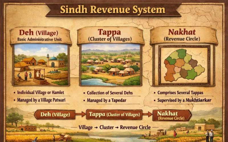
Sindh’s revenue system organizes land across a hierarchy of administrative units, from the province all the way down to the individual survey number. Each layer has a defined function, and the three terms in question sit at different points in that hierarchy.
Understanding where Deh, Tappa, and Nakhat fit within the broader system makes it much easier to use them correctly when dealing with the Patwari, submitting online searches, or reading any official revenue document. The land revenue system in rural Pakistan follows a nested structure that has its roots in the British-era revenue settlement, and Sindh’s terminology reflects the specific adaptations made during the Sindh settlement surveys.
The hierarchy from top to bottom runs as follows:
- Province (Sindh)
- Division
- District (Zila)
- Taluka (equivalent to Tehsil in Punjab)
- Deh (revenue village)
- Survey number and Hissa number (individual plot identifiers)
Tappa and Nakhat operate within this hierarchy as sub-units or groupings that help manage the administration of large or complex revenue estates. Their use varies across districts, and not every Deh uses all three terms.
What a Deh Is in Sindh Revenue
The Deh is the foundational unit of land administration in Sindh. Every piece of agricultural or rural land in the province belongs to a specific Deh, and all land records, survey numbers, ownership entries, and cadastral maps are organized and referenced by Deh name.
In simple terms, a Deh is the revenue village. It is a defined geographic area with recognized boundaries, maintained as a distinct cadastral unit within a Taluka. The Patwari responsible for a particular Deh maintains all land records for that area, including the ownership register, the cultivation record, the field map (Shajra), and the revenue demand register.
Every survey number in Sindh belongs to one and only one Deh. When you search for land records through LARMIS or request a Fard from the Patwari, you must specify the Deh name before any search can be conducted. If you provide the wrong Deh name, you will either get no results or, worse, results for a different piece of land that happens to share the same survey number in a different revenue village.
The Deh name is recorded on every official land document, including the Fard ownership certificate, the Shajra map, and the Jamabandi. It is the primary geographic anchor of your land record and must be stated accurately in every official application.

What a Tappa Is and Where It Is Used
A Tappa is a grouping of multiple Dehs within a Taluka, used as an intermediate administrative unit for revenue management and supervision purposes. Not all Talukas in Sindh use the Tappa designation, but in districts where land administration is complex and the number of Dehs is large, Tappas help organize the supervisory workload across Patwari circles.
In practical terms, a Tappa functions as a cluster of revenue villages placed under common oversight. A Qanungo, who supervises multiple Patwari Halqas, may have their jurisdiction defined by Tappa boundaries. This means that when you escalate a record correction or a complaint about a Patwari from a particular Deh, the Qanungo responsible will be the one whose Tappa covers that Deh.
The role of the Qanungo in Pakistan’s revenue system is to supervise Patwari record-keeping across the Dehs in their assigned area. Where Tappas are the defined supervisory unit, knowing your Tappa helps you identify the correct Qanungo office when Patwari-level resolution is not available.
Tappa numbers or names appear on older land documents, particularly those prepared during or shortly after British-era settlement surveys. On more recent documents and digital portals, the Tappa field may or may not appear depending on whether the district uses this administrative layer actively.
What a Nakhat Is in Sindh Land Records
A Nakhat is a sub-division of a Deh. Where a Deh is large in area or contains a high number of survey numbers, it may be divided into Nakhats for internal administrative convenience. Each Nakhat within a Deh covers a specific geographic portion of the revenue village and is identified by a name or number.
Think of the Nakhat as a neighbourhood or zone within the revenue village. The Shajra map of the Deh may be divided into separate sheets by Nakhat, and survey numbers within the Deh will be tagged to a specific Nakhat to help locate them on the map and in the physical register.
Not every Deh has Nakhats. Smaller Dehs with fewer survey numbers typically have no Nakhat division and all survey numbers fall directly under the Deh without any sub-grouping. Larger Dehs, particularly those in districts with dense agricultural land use, are more likely to use Nakhats to keep their records manageable.
When a Nakhat exists, specifying it correctly when requesting a certified copy or conducting an online search narrows the search to the correct portion of the Deh register, preventing confusion between survey numbers that might appear in different Nakhats with similar numbering patterns.
Why These Terms Matter for Land Transactions
These are not just administrative labels. In the context of a property purchase, an inheritance settlement, or a boundary dispute, getting these geographic identifiers right is the difference between a clean transaction and a costly mistake.
Consider a situation where someone buys land in a large Deh that has multiple Nakhats. If the sale deed or mutation application states only the survey number without specifying the correct Nakhat, the revenue office may process the mutation against the wrong portion of the Deh register. The ownership record then appears in the wrong Nakhat, and correcting that kind of administrative error requires a fresh application and a revenue inquiry that could take months.
Similarly, if a Tappa designation is required on a particular form and you leave it blank, the application may be routed to the wrong Qanungo circle, delaying processing while the file is transferred to the correct office. Before submitting any application involving a land record in Sindh, confirm all three identifiers: the Deh, the Tappa if applicable, and the Nakhat if the Deh is subdivided.
- Confirm the exact Deh name from your existing Fard or any previous land document
- Check whether the Deh falls within a named Tappa by asking at the Tehsildar’s office or checking the LARMIS portal
- Ask the Patwari whether the survey number in question falls within a specific Nakhat of the Deh
- Record all three on every application, even if the form does not explicitly require the Tappa or Nakhat field
How to Find Your Deh, Tappa, and Nakhat
If you do not already have a document that states these identifiers, there are several reliable ways to confirm them before approaching any revenue office.
The most direct method is to bring your survey number and the seller’s name or a previous Fard to the Patwari Halqa office responsible for the area where the land is located. The Patwari can confirm the Deh, Tappa, and Nakhat from the physical register.
For digitized districts, the LARMIS portal maintained by the Board of Revenue Sindh allows you to search by district and Taluka. Once you narrow down to the correct Taluka, the Deh names within it are listed and searchable. If the portal includes Nakhat-level data for your district, it will appear as a filter option within the Deh search.
Older property documents such as a previous sale deed or mutation order almost always state the Deh and often the Nakhat. These documents are the fastest reference if you already have them. The register of rights in land revenue prepared during each Jamabandi revision will also carry all three identifiers for every survey number it covers.
Deh Boundaries and Their Importance in Disputes
Deh boundaries are not arbitrary lines on a map. They are legally defined demarcations that determine which Patwari is responsible for which land and which revenue court has jurisdiction over disputes involving that land.
When a dispute involves land near the boundary of two Dehs, establishing which Deh the contested survey number belongs to is the first question the revenue officer must resolve. The Shajra map for each Deh shows its outer boundary, and the survey records confirm which side of that boundary each survey number falls on.
Boundary marks in land revenue serve a similar function at the individual plot level, but Deh boundaries define the outer frame within which all those plot-level marks exist. A boundary dispute that crosses a Deh line involves two separate Patwari Halqas and requires the Qanungo or the Tehsildar to coordinate between the two Patwaris during any field inquiry.
If you are dealing with a land encroachment situation near a Deh boundary, confirming which Deh your land officially falls within is the first step in identifying the correct officer to approach and the correct records to produce.

Common Errors Involving These Terms and How to Avoid Them
Most errors involving Deh, Tappa, and Nakhat fall into one of a few predictable patterns, and all of them are avoidable with basic verification before filing any document.
The most common error is using an informal or colloquial name for the Deh rather than its official revenue name. Many Dehs in Sindh are known locally by a different name from their official cadastral designation. Using the informal name on a legal application can cause the application to be routed incorrectly or rejected.
Another frequent mistake is omitting the Nakhat when it is required, particularly in large Dehs where two different Nakhats may contain survey numbers with the same or similar numbers. Always verify with the Patwari whether a Nakhat designation exists for your land before submitting any document.
A third error occurs when land is transferred to a buyer who is told only the survey number without being given the Deh and Nakhat. Without those identifiers, the new owner cannot independently verify or access their own record, which creates unnecessary dependence on the seller or a middleman for basic information they are entitled to have. When completing any property purchase in Pakistan, insist on receiving the complete set of identifiers: district, Taluka, Deh, Tappa if applicable, Nakhat if applicable, survey number, and Hissa number.
Frequently Asked Questions
What is a Deh in Sindh’s land revenue system
A Deh is the basic unit of land administration in Sindh, equivalent to a revenue village. Every piece of agricultural or rural land in Sindh belongs to a specific Deh, and all land records including ownership registers, field maps, mutation registers, and revenue demand records are organized and referenced by Deh name. The Patwari assigned to a Deh maintains all records for that area. When searching land records online or submitting any application at the revenue office, the Deh name is a mandatory identifier without which the search or application cannot proceed.
What is the difference between a Tappa and a Nakhat in Sindh
A Tappa is a group of multiple Dehs within a Taluka, used as an intermediate administrative unit to organize supervisory responsibilities across Qanungo circles. It sits above the Deh in the hierarchy. A Nakhat is a sub-division within a single Deh, used to partition large revenue villages into manageable geographic zones for internal record-keeping. It sits below the Deh in the hierarchy. Not all Talukas use Tappas, and not all Dehs are divided into Nakhats. Their presence depends on the size and administrative complexity of the area.
Why do I need to know my Deh name to search land records in Sindh
Land records in Sindh are organized by Deh at every level of the revenue system. Survey numbers repeat across different Dehs, meaning the same number can exist in multiple revenue villages within the same Taluka. Without specifying the Deh, a search will either return no results or pull records for a different piece of land with the same survey number in a different revenue village. The Deh name is the primary geographic anchor that makes any survey number unique and searchable.
How do I find out which Tappa and Nakhat my land belongs to
The most reliable way is to check any existing land document you hold, such as a previous Fard, sale deed, or mutation order. These documents typically state the Deh and often the Nakhat. For Tappa information, visit the Tehsildar’s office or the local Patwari Halqa and ask directly. On the LARMIS online portal for digitized districts, the Tappa and Nakhat fields appear as selectable filters once you have chosen your Taluka and Deh. If no document is available, the Patwari responsible for the Deh can confirm all identifiers from the physical register.
Can errors in Deh or Nakhat on a land document cause legal problems
Yes. If a sale deed, mutation application, or Fard request states an incorrect Deh or Nakhat, the resulting record may be processed against the wrong portion of the register or the wrong Deh entirely. This creates a discrepancy between the physical land and the official record that requires a formal inquiry and correction order from the Tehsildar to resolve. In serious cases where the error is not caught early, it can lead to overlapping ownership claims or disputes with other landowners whose correctly recorded land appears in the same system entry. Always verify all geographic identifiers before submitting any legal or revenue document.